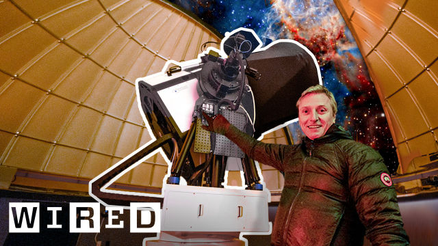
All the Ways Google Gets Street View Images
Released on 06/20/2022
[Narrator] 102 countries, seven continents,
10 million miles of road.
In 15 years,
Google Street View has circled the planet 400 times.
Here you can see where we've mounted the Street View car
onto a three-wheel tricycle.
Here it's been mounted to a snowmobiles.
One of our earliest trackers.
A trolley through museums.
Places that we expect that are to be a lot of change,
we try to drive those areas more frequently.
There are other areas of the world where we still
have to go back and refresh that imagery again.
[Narrator] Let's walk through 15 years of gadgets and gear
to understand the tools Google Street View uses
to map the world.
Maps are fundamentally about where things are.
Think about a satellite map, or even the map
that you draw on a napkin for your friend.
You're talking about where things are
and where they are in relation to each other.
[Narrator] And in that sense, Street View was different.
It promised an immersive on-the-ground experience
of far-flung locals.
Street View was the brainchild
of Google co-founder, Larry Page.
He had what was a pretty crazy idea at the time
that you should enable people to explore the world right
from their computers.
He actually collected the first Street View imagery.
He used a camcorder and drove around the streets
around the Google office and brought this back
for the engineers to play with.
And the engineers built a custom prototype camera system
that had multiple camera units and multiple laser scanners.
The whole thing weighed 500 pounds.
The team used this to collect imagery around the Bay Area.
The very first version, which had a small
four megapixel camera, it just took pictures
and we had to figure out exactly
where these pictures were taken using a GPS unit
that followed along with the car.
The idea was how can we stitch this together
into a seamless experience that can let people
explore the world.
The lights turned on for Street View in may of 2007.
That was when we had the first consumer-facing release
with five Street View cities worth of imagery collected.
[Narrator] San Francisco, New York, Las Vegas, Miami,
and Denver were the first, but the project expanded,
covering more countries and thousands of miles of streets,
all using pretty much the same underlying process.
At the most basic level, it's all about collecting imagery
of the world and processing this into one seamless model.
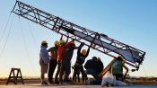
A Street View car starts as a regular car
that you could buy.
We mount a custom roof rack onto the top
and then the camera gets mounted on a mast
that can be raised and lowered.
The Street View camera has seven lenses
and it takes full 360-degree panoramic shot
a couple times a second, so you'd be able to traverse
the length of a road from picture to picture to picture,
using a technique called photogrammetry,
which is a really old technique, actually from the 1800s.
You can take measurements from photos
and you can basically figure out where objects are,
how big they are, how far apart they are.
There's a cable that comes off the camera system
and goes into the backseat where it connects
to the processing system and the hard drives
for storing all of the imagery data.
In the back, there were boxes of CPUs and hard drives
in them that would collect all of the data.
This typically took up a big portion
of the backseat of the car and it's getting stored
on, basically, on the hard disk.
This information is sent in batch
and then it's fed into our imagery processing pipelines.
The cameras themselves have gotten much better.
Not only have they gotten higher resolution,
going from 4.8 megapixels, to a 45 megapixel camera,
75, up to 140 megapixels.
Their responsiveness in low light is much better.
[Narrator] Apart from improvements in the cameras,
the game-changing tech to the Street View system
was the addition of LIDAR scanners,
first in 2008 and updated in 2013.
The LIDAR works with, you know, millimeter accuracy.
They're laser radars.
They have invisible laser beams
that shoot out and map the world in 3D,
as the car moves down the street.
So it helps us measure where the curbs are, or even
where there are lines of paint in the middle of the road.
All this information comes back
and helps us build this very precise, highly detailed
3D reconstruction of the world.
Every route is planned in advance.
This is actually important from a privacy perspective.
We try to standardize our Google Street View hardware
as much as possible, but sometimes there are local quirks
that mean we have to introduce something
a little bit different.
This is our main car that we use in North America
and the mast on top of the car is pretty tall.
This is so the camera can see over parked cars
that might be on the side of the street.
When we first took this car to Japan, we ran into a problem.
The streets are very narrow and oftentimes,
people put up fences in front of their yard
so that their yard won't be visible from the street
and we discovered that the Street View camera
was actually seeing over these fences into people's yards.
So we came up with a custom rig for the Japan market
and you can see that this car has a much lower mast.
[Narrator] Another milestone expansion of the program
was tracker gear, which took image-gathering
off road in 2012.
We realized that there were so many important places
on earth where you simply couldn't drive a car.
Even in a city, there are narrow alleys,
there are pedestrian walking pads.
We'd like to take you inside transit stations,
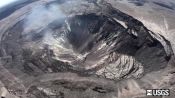
or maybe even inside a museum, or out into the wilderness,
to the top of Machupicchu, and the top of Mont Blanc,
down into the Amazon rainforests,
and underwater by the Great Barrier Reef,
or up in the International Space Station.
The Street View tracker is basically
a Street View camera system that's attached to a backpack.
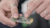
Here you can see the camera unit on top with the lenses.
Here you can see a GPS unit
and these are our laser scanners.
This is the processing unit.
And what you see on the back here is a big heat sink
because it takes a lot of processing to handle
all this imagery and the unit can get hot.
You actually put this on, wearing the straps.
It's relatively comfortable to wear.
But, you know, it's not the lightest thing,
weighing in at about 35 pounds.
You can just walk naturally and it will automatically
snap photos as you're walking down the path.
You can be tipping from side to side
and you don't want the pictures to come out blurry.
So we use a lot of smart software algorithms.
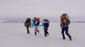
[Narrator] The typical trucker outing takes a few hours,
unless it's a hike down into the Grand Canyon.
That'll take a tracker 10 days.
Google collects this imagery themselves
through staff trackers,
through a network of third-party contractors,
or by tapping a community of contributors
who use their own 360 cameras.
My favorite story about the Street View tracker
is about the Faroe Islands.
Some enterprising folks who live there,
they wanted the Faroe Islands to be on Street View as well.
We actually sent them the Street View equipment
and they used sheep to carry the Street View camera
around Sheep view.
One thing that we tried was putting high-definition cameras
that were facing to the sides, so we could read
small print that was on the store fronts of businesses.
Think about opening hours that are on the door
of a business, that it's really hard to see from the street.
[Narrator] This side profile camera configuration
was paired with machine learning
and image recognition software,
which was already in Google's wheelhouse.
The engineers who first worked on this project
had actually been working on
the Google Books search project.
They were experts in processing imagery
and the book search project was trying to digitize
all the world's books in libraries.
So these people knew how to work with imagery.
And at first, we had humans looking at this imagery,
combined with thousands of other data sources
in order to build the roads and the business listings
that you see on Google Maps.
But the world is a really big place, so it wasn't too long
before we started introducing machine learning
to look at the images and automatically extract information.
Blurring and privacy protection
has been built in pretty much from the start.
This is a process that's fully automatic.
All of the people's faces, all the license plates,
these are blurred through automatic algorithms
because, otherwise, the scale of processing this with humans
would just be too great.
[Narrator] Recently, Google unveiled for us
the latest camera, set to roll out on Street View cars
over the next year.
Our current generation cameras,
they're designed for specific models of car
that need to have a custom roof rack.
With this, we can send it around the world.
It has handles to make it easy to pick up.
The whole thing weighs less than 15 pounds.
And one of the key things about this
is it can be mounted on top of any vehicle at all.
We can give it to a third-party
and they can put it on any car that has a roof rack.
There are seven lenses arranged around the outside
and one that's pointing upwards from the top.
As the camera moves down the street,
or on top of a backpack,
it takes a full 360-degree panorama.
These are heat sinks.
We've taken all of the processing power
that used to take up the entire backseat of a car
and we've shrunk it down and we've stuck it inside
the camera unit, so this is all you need
in order to go collect Street View imagery.
[Narrator] Google is innovating on the software side, too,
with Immersive View.
We launched Immersive View, which is all of the billions
of Street View images and aerial photos.
Let's say, you're planning a trip to London.
We can take you to Westminster and you can see
where's Big Ben, and where's the London Eye,
and where are they in relation to each other.
We can then overlay additional information
on top of this model of the world.
If you wanna see what it looks like with the sun coming
from one direction or the sun coming from another direction,
using all of this imagery that we've collected,
we can actually put these experiences
into what we've collected from Street View.
And when you're ready to choose a restaurant,
we can fly you down to street level and show you
real-time busyness and these future, rich, immersive
experiences, this is what Street View will be empowering.
And hopefully it's helped people learn more
about places around the world,
about other people's communities,
and about their fellow citizens.
How the Disco Clam Uses Light to Fight Super-Strong Predators

Architect Explains How Homes Could be 3D Printed on Mars and Earth

Scientist Explains How Rare Genetics Allow Some to Sleep Only 4 Hours a Night

Scientist Explains Unsinkable Metal That Could Prevent Disasters at Sea

Is Invisibility Possible? An Inventor and a Physicist Explain

Scientist Explains Why Her Lab Taught Rats to Drive Tiny Cars
Mycologist Explains How a Slime Mold Can Solve Mazes

How the Two-Hour Marathon Limit Was Broken

Research Suggests Cats Like Their Owners as Much as Dogs

Researcher Explains Deepfake Videos

Scientist Explains How to Study the Metabolism of Ultra High Flying Geese

Hurricane Hunter Explains How They Track and Predict Hurricanes
Scientist Explains Viral Fish Cannon Video
A Biohacker Explains Why He Turned His Leg Into a Hotspot
Scientist Explains What Water Pooling in Kilauea's Volcanic Crater Means

Bill Nye Explains the bet365体育赛事 Behind Solar Sailing

Vision Scientist Explains Why These Praying Mantises Are Wearing 3D Glasses

Why Some Cities Are Banning Facial Recognition Technology

Scientist's Map Explains Climate Change

Scientist Explains How Moon Mining Would Work

Scientist Explains How She Captured Rare Footage of a Giant Squid

Doctor Explains How Sunscreen Affects Your Body

Stranger Things is Getting a New Mall! But Today Malls Are Dying. What Happened?
The Limits of Human Endurance Might Be Our Guts
Meet the First College Students to Launch a Rocket Into Space

Scientist Explains Why Dogs Can Smell Better Than Robots

A Harvard Professor Explains What the Avengers Can Teach Us About Philosophy

NASA Twin Study: How Space Changes Our Bodies

What the Black Hole Picture Means for Researchers

Scientist Explains How to Levitate Objects With Sound

Why Scientists and Artists Want The Blackest Substances on Earth

Biologist Explains How Drones Catching Whale "Snot" Helps Research

Researcher Explains Why Humans Can't Spot Real-Life Deepfake Masks

Doctor Explains What You Need to Know About The Coronavirus
VFX Artist Breaks Down This Year's Best Visual Effects Nominees

How Doctors on Earth Treated a Blood Clot in Space

Scientist Explains Why Some Cats Eat Human Corpses

Voting Expert Explains How Voting Technology Will Impact the 2020 Election

Doctor Explains What You Need to Know About Pandemics

ER Doctor Explains How They're Handling Covid-19

Why This Taste Map Is Wrong

Q&A: What's Next for the Coronavirus Pandemic?

Why Captive Tigers Can’t Be Reintroduced to the Wild

How Covid-19 Immunity Compares to Other Diseases

5 Mistakes to Avoid as We Try to Stop Covid-19

How This Emergency Ventilator Could Keep Covid-19 Patients Alive
Why NASA Made a Helicopter for Mars

Theoretical Physicist Breaks Down the Marvel Multiverse

Former NASA Astronaut Explains Jeff Bezos's Space Flight

Physics Student Breaks Down Gymnastics Physics

What Do Cities Look Like Under a Microscope?

Inside the Largest Bitcoin Mine in The U.S.

How Caffeine Has Fueled History
How Mushroom Time-Lapses Are Filmed

Why You’ll Fail the Milk Crate Challenge

Why Vegan Cheese Doesn't Melt

How 250 Cameras Filmed Neill Blomkamp's Demonic

How Meme Detectives Stop NFT Fraud

How Disney Designed a Robotic Spider-Man

How Online Conspiracy Groups Compare to Cults

Dune Costume Designers Break Down Dune’s Stillsuits

Korean Phrases You Missed in 'Squid Game'

Why Scientists Are Stress Testing Tardigrades

Every Prototype that Led to a Realistic Prosthetic Arm

Why the Toilet Needs an Upgrade

How Animals Are Evolving Because of Climate Change

How Stop-Motion Movies Are Animated at Aardman

Astronomer Explains How NASA Detects Asteroids

Are We Living In A Simulation?

Inside the Journey of a Shipping Container (And Why the Supply Chain Is So Backed Up)

The bet365体育赛事 of Slow Aging

How Nose Swabs Detect New Covid-19 Strains

Samsung S22 Ultra Explained in 3 Minutes

The bet365体育赛事 Behind Elon Musk’s Neuralink Brain Chip

Every Prototype to Make a Humanoid Robot

Chemist Breaks Down How At-Home Covid Tests Work

A Timeline of Russian Cyberattacks on Ukraine

VFX Artist Breaks Down Oscar-Nominated CGI

Why Smartphones Night Photos Are So Good Now

We Invented the Perfect WIRED Autocomplete Glue

How Everything Everywhere All at Once's Visual Effects Were Made

How Dogs Coevolved with Humans
How an Architect Redesigns NYC Streets

Viking Expert Breaks Down The Northman Weapons

J. Kenji López-Alt Breaks Down the bet365体育赛事 of Stir-Fry

How A.I. Is Changing Hollywood

How Trash Goes From Garbage Cans to Landfills

Veterinarian Explains How to Prevent Pet Separation Anxiety

The bet365体育赛事 Behind Genetically Modified Mosquitoes

How Scientists & Filmmakers Brought Prehistoric Planet's Dinosaurs to Life

All the Ways Google Gets Street View Images

How Public Cameras Recognize and Track You

How the Nuro Robotic Delivery Car Was Built

Biologist Explains the Unexpected Origins of Feathers in Fashion

Surgeons Break Down Separating Conjoined Twins

Former Air Force Pilot Breaks Down UFO Footage

Bug Expert Explains Why Cicadas Are So Loud

The Best of CES 2021

Health Expert Explains What You Need to Know About Quarantines

Scientist Explains How People Might Hibernate Like Bears
Could a Chernobyl Level Nuclear Disaster Happen in the US?

Neuroscientist Explains ASMR's Effects on the Brain & The Body

Why Top Scientists Are Pretending an Asteroid is Headed for Earth

Epidemiologist Answers Common Monkeypox Questions

Bill Nye Breaks Down Webb Telescope Space Images

How This Humanoid Robot Diver Was Designed

Every Trick a Pro GeoGuessr Player Uses to Win

How NASA Biologists Plan to Grow Plants on the Moon

How FIFA Graphics & Gameplay Are Evolving (1993 - 2023)

How a Vet Performs Dangerous Surgeries on Wild Animals

This Heart is Not Human

How Entomologists Use Insects to Solve Crimes

Former NASA Astronaut Breaks Down a Rocket Launch

Chess Pro Explains How to Spot Cheaters

Why Billionaires Are Actually Ruining the Economy

How to Keep Your New Year’s Resolutions for More Than a Week

The Biology Behind The Last of Us

English Teacher Grades Homework By ChatGPT

All the Ways a Cold Plunge Affects the Body

Spy Historian Debunks Chinese Spy Balloon Theories

A.I. Tries 20 Jobs | WIRED

Mathematician Breaks Down the Best Ways to Win the Lottery

Why Music Festivals Sound Better Than Ever

Pro Interpreters vs. AI Challenge: Who Translates Faster and Better?

Why The Average Human Couldn't Drive An F1 Car

Atomic Expert Explains "Oppenheimer" Bomb Scenes

Every 'Useless' Body Part Explained From Head to Toe

How Pilots and Scientists Are Thinking About the Future of Air Travel

How To Max Out At Every Fantasy Football Position (Ft. Matthew Berry)

All The Ways Mt. Everest Can Kill You

How Fat Bears Bulk Up To Hibernate (And Why We Love To See It)

Why Vintage Tech Is So Valuable To Collectors

8 Photos That Tell The History of Humans In Space

How Every Organ in Your Body Ages From Head to Toe

Why AI Chess Bots Are Virtually Unbeatable (ft. GothamChess)
How Mind-Controlled Bionic Arms Fuse To The Body

Historian Breaks Down Napoleon's Battle Tactics